

Published on: 08/20/2025

Description
Fire season arrived all at once in Madison County with five fires igniting after a series of early morning thunderstorms on Aug. 13 and an afternoon storm on the afternoon of Aug. 16. At the time of this writing no structures have been lost to the fires. Here is how the week played out on a fire by fire account. Please make sure to visit inciweb.wildfires.gov to get the most current information on each of the fires.
The Horn Fire: South Madison County
Located between Cliff Lake and Hwy 87 in South Madison County the Horn Fire was reported at 2:24 p.m. on Wednesday Aug. 13. Lightning is the reported cause of the fire and it spread rapidly through grass and sagebrush causing the closure of HWY 87 between Hwy 287 and Island Park ID.
On Aug. 14 at 5 p.m. the Madison County Sheriff’s Office issued an emergency evacuation order for all residents east of Hwy 87 and south of US Hwy 287 after an afternoon of gusty winds raised fears the fire would jump across the perimeter set at Hwy 287. Rumors of the fire jumping the road were dispelled and at 1:27 a.m. on Aug. 15 Hwy 87 was reopened to traffic and the evacuation order was lifted.
Ten fire engines, two type two crews, a water tender, a bulldozer and two helicopters were involved in the suppression of the fire which is labeled as 75% contained as of Aug. 18 at 3:45 p.m.
With hot dry and potentially windy conditions forecast for the upcoming week, the public is urged to use caution when in the area and do not stop on roadways or use drone technology in the area as it may interfere with airborne fire suppression efforts.
Two Tobacco Root Mountain Fires
Two separate fires ignited in the Tobacco Root Mountains leading to rumors that the fires would merge. As of the morning of Aug. 18, the fires were roughly five miles apart and Beaverhead-Deerlodge National Forest public information officer Michelle Peterson indicated that it is unlikely the fires will merge but that further mapping efforts will provide a more detailed forecast in the coming days.
The Bivens Creek Fire
The Bivens Creek Fire is described as being 10 miles East of Sheridan Southwest of Ramshorn Mountain on the east side of Bivens Creek Ridge Road. As of 7:15 a.m. on Aug. 19 the fire was shown to be 2,266 acres with 0% containment. Command of the fire was handed off to Northern Rockies Complex Incident Team Six on 7 p.m. Aug. 17.
The fire is burning through stands of Blister Rust killed trees in rugged terrain. The fire remained mostly active West of the Ramshorn Drainage burning through high alpine heavy, dead and down subalpine fir timber. Firefighters are prepping roads and assessing for structure protection. They are looking for opportunities to build a perimeter.
Sunday’s lower temperatures and elevated humidity combined with several wet thunderstorms moving through the area helped to slow the fires' growth, but the return of fire friendly weather conditions means that more smoke and fire activity is expected to occur this week. Pony, Harrison and Bozeman are expected to be significantly impacted by the smoke produced by the fire.
At the time of this writing, crews are working along the west flank of the fire to protect structures in Ramshorn, Bivens Creek and Harris Creek as well as the Ramshorn Watershed.
The Cloudrest Fire
Located nine miles Northeast of Sheridan and 12 miles East of Twin Bridges, the Cloudrest fire is mapped at 1,182 acres as of Aug. 18 at 8:24 a.m. and is burning slowly through a high altitude bowl and may access a large area of blown down timber at the top of South Willow Creek as fire friendly conditions return.
Crews have put a high priority on protecting the headwaters of Indian Creek, which is the municipal watershed for the Town of Sheridan. They are building secondary containment lines and improving existing two track roads to help contain the fire.
The fire is also under the command of Northern Rockies Complex Incident Team Six who will also assist with initial attack on new fire starts in the area.
As of Aug. 19 at 9:30 a.m. fire managers are preparing to insert a hotshot crew who will remain in the field for four to five days, building a direct line on the fire during the day and sleeping at a spike camp near the fire at night. They will focus on the Indian Creek drainage to ensure there is minimal damage to the watershed. Crews have also identified opportunities to build secondary containment lines along existing two track roads with heavy equipment if necessary to implement that plan.
The McAllister Fire
On the afternoon of Aug. 16 a thunderstorm blew through Ennis and a lightning strike sparked a grass fire on Norris Hill. The fire spread quickly forcing the closure of Hwy 287 and prompting evacuation warnings for the Shining Mountain West and Bradley Creek areas. As of Aug. 16 at 4:05 p.m. the fire had consumed 3,500 acres and was 50% contained according to the National Interagency Fire Center. As of that time evacuation warnings remain in effect for Bradley Creek, Shining Mountain West and Hwy 287 between mile markers 61 and 64.
Hwy 287 has reopened to traffic, but citizens are urged to use caution when passing through the area as fire friendly conditions including low humidity and potential for gusty winds cause the incident to grow quickly.
Fire crews are working to create a roughly 180 foot perimeter of cold ground to buffer the spread of the blaze. They are also working to suppress hot spots within the interior of the fire that have the potential to ignite again.
The Elk Creek Fire
The Elk Creek Fire is estimated at 273 acres near the Madison and Gallatin County line East of Hwy 84 and Cherry Creek Road. As of Aug. 16 at 5:57 p.m. there is no containment reported and no details regarding the movement of the fire. The incident sparked on Aug. 16 after a thunderstorm moved through the area.
Current information about the fires burning around Madison County is available at www.inciweb.wildfires.gov.

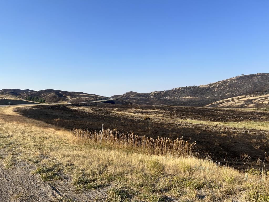
Some of the burned area from McAllister Fire on Norris Hill on Tuesday morning. Drivers are reminded to use caution and heed speed limits as conditions can change rapidly.
PHOTO BY CORI KOENIG

The Horn Fire at night.
PHOTO COURTESY DOROTHY LISS

The smoke plumes from the Bivens Creek and Cloudrest Fires, seen here from the Ennis Fishing Access, could be seen as far away as South Cameron.
PHOTO BY MADISON GOETTLE

The Horn Fire caused the closure of Hwy 87 and the evacuation of residents in the area.
PHOTO BY MATI BISHOP
News Source : https://www.madisoniannews.com/news/one-week-five-fires-over-10000-acres-burned
Other Related News

08/20/2025
HELENA Mont The Montana Department of Livestock MDOL reported a brucellosis case in a Bea...

08/20/2025
Search teams recovered Tuesday the body of a boater who disappeared after jumping into Fl...

08/20/2025
The 2025 Picnic in the Park Summer Concert Series wraps up Wednesday Aug 20 at Depot Park...

08/20/2025
A plan to prevent development near Smith Lake and Swift Creek has hit a roadblockWhitefis...

08/20/2025
Kalispell Public Schools will have 907 million for operations during the 2025-26 school y...
Follow

Download Our App


Copyright 2023 © Meet Montana. All Rights Reserved